Showing posts with label Greenland. Show all posts

Saturday, July 25, 2015

Greenland’s undercut glaciers melting faster than thought

A press release from NASA: Greenland's glaciers flowing into the ocean are grounded deeper below sea level than previously measured, allowing intruding ocean water to badly undercut the glacier faces. That process will raise sea levels around the world much faster than currently estimated, according to a team of researchers led by Eric Rignot of the University of California, Irvine (UCI), and NASA's Jet Propulsion Laboratory, Pasadena, California.

The researchers battled rough waters and an onslaught of icebergs for three summers to map the remote channels below Greenland's marine-terminating glaciers for the first time. Their results have been accepted for publication in the journal Geophysical Research Letters and are now available online.

"Measurements are challenging to obtain beneath hundreds of meters of seawater in poorly charted, ice-infested fjords," Rignot wrote. He and co-authors Ian Fenty of JPL, Cilan Cai and Yun Xu of UCI, and Chris Kemp of Terrasond Ltd., Seattle, obtained and analyzed around-the-clock measurements of the depth, salinity and temperature of channel waters and their intersection with the coastal edge of Greenland's ice sheet.

The team found some glaciers perched on giant earthen sills, protecting them from the punishing salt waters for now, while others were being severely eroded out of sight beneath the surface, meaning they could collapse and melt much sooner.  "Numerical ice sheet models do not take into account these interactions and as a result underestimate how fast the glaciers will respond to climate warming," said Rignot....

Glaciologists from the University of California, Irvine, and JPL mapped remote Greenland fjords by ship in 2014. Their findings show that Greenland's glaciers are likely to be melting faster than previously thought. Credits: UCI/Maria Stenzel

Sunday, April 19, 2015

Greenland darkening to continue

A press release from City College of News York: Darkening of the Greenland Ice Sheet is projected to continue as a consequence of continued climate warming, Dr. Marco Tedesco, a City College of New York scientist, said at the European Geosciences Union (EGU) General Assembly in Vienna today.

Tedesco told a press conference in the Austrian capital that the projection is based on a model that only accounts for the effects of warming on snow grain size and melting.

An associate professor in City College’s Division of Science and head of its Cryospheric Processes Laboratory that he founded, Tedesco is an authority on the Greenland Ice Sheet where he has conducted annual research.

He noted that a darkening of the Greenland Ice Sheet associated with increasing temperatures and enhanced melting occurred between 1996 and 2012. It was promoted by:

  • Extensively and persistently increased surface snow grain size;
  • The expansion and persistency of the areas of exposed bare ice and by the increased surface impurities concentration associated with the appearance of dirty ice;
  • Increased impurities concentrations due to consolidation with snowmelt. 

Tedesco, however, added that his research had not found any evidence that points to either increased atmospheric deposition of impurities or to the number of fires over Eurasia and North America as being factors....

NASA photo of Greenland ice flowing around a ridge of bedrock

Sunday, January 25, 2015

Greenland Ice: The warmer it gets the faster it melts

Space Daily via SPX: Melting of glacial ice will probably raise sea level around the globe, but how fast this melting will happen is uncertain. In the case of the Greenland Ice Sheet, the more temperatures increase, the faster the ice will melt, according to computer model experiments by Penn State geoscientists.

"Although lots of people have thought about sea level rise from the ice sheets, we don't really know how fast that will happen," said Patrick Applegate, research associate, Penn State's Earth and Environmental Systems Institute.

If all the ice in the Greenland Ice Sheet melts, global sea level would rise by about 24 feet. In the last 100 years, sea level in the New York City area has only increased by about one foot. However, storm surges from hurricanes stack on top of this long-term increase, so sea level rise will allow future hurricanes to flood places where people are not ready for or used to flooding. A vivid example occurred during Hurricane Sandy when parts of the New York City subway tunnel system flooded.

Greenland might be especially vulnerable to melting because that area of the Earth sees about 50 percent more warming than the global average. Arctic sea ice, when it exists, reflects the sun's energy back through the atmosphere, but when the sea ice melts and there is open water, the water absorbs the sun's energy and reradiates it back into the air as heat.

Arctic sea ice coverage has decreased over the last few decades, and that decrease will probably continue in the future, leading to accelerated temperature rise over Greenland. Floating ice does not add to sea level, but the Greenland Ice Sheet rests on bedrock that is above sea level.

Feedbacks in the climate system cause accelerated temperature rise over the Arctic. Other feedbacks in the Greenland Ice Sheet that contribute to melting include height-melting feedback. A warm year in Greenland causes more melt around the edges of the ice sheet, lowering the surface. The atmosphere is warmer at lower altitudes, so the now lower surface experiences even more melting. This process can lead to accelerated ice melt and sea level rise....

A glacier seen from offshore near Amassalik, Greenland, shot by Christine Zenino Christine Zenino ,Wikimedia Commons via Flickr, under the Creative Commons Attribution 2.0 Generic license

Sunday, May 25, 2014

Hidden Greenland canyons mean more sea level rise

NASA: Scientists at NASA and the University of California, Irvine (UCI), have found that canyons under Greenland's ocean-feeding glaciers are deeper and longer than previously thought, increasing the amount of Greenland's estimated contribution to future sea level rise.

"The glaciers of Greenland are likely to retreat faster and farther inland than anticipated, and for much longer, according to this very different topography we have discovered,” said Mathieu Morlighem, a UCI associate project scientist who is lead author of the new research paper. The results were published Sunday in the journal Nature Geoscience.

Ice loss from Greenland has accelerated during the last few decades. However, older ice sheet models predicted the speedup would be temporary because the glaciers would soon melt back onto higher ground and stabilize. The models projected that Greenland's contribution to global sea level rise would therefore be limited.

Morlighem's new topography shows southern Greenland's ragged, crumbling coastline is scored by more than 100 canyons beneath glaciers that empty into the ocean. Many canyons are well below sea level as far as 60 miles (100 kilometers) inland. Higher ground, where glaciers could stabilize, is much farther from the coastline than previously thought. The finding calls into question the idea that the recent accelerated ice loss will be short lived.

..."We have been able to make a quantum leap in our knowledge of bed topography beneath ice sheets in the last decade, thanks to the advent of missions like NASA's Operation IceBridge in combination with satellite data on the speed these ice sheets are flowing," said coauthor Eric Rignot of UCI and NASA's Jet Propulsion Laboratory (JPL), Pasadena, California.

The same research team reported new findings on glacial melt in West Antarctica last week. "Together the papers illustrate clearly the globe’s ice sheets will contribute far more to sea level rise than current projections show,” said Rignot...

Kejser Franz Josef Fjord near Stensjö Bjerg, Greenland Nationalpark. Shot by Erik Christensen, Wikimedia Commons, under Creative Commons 3.0 license

Thursday, May 8, 2014

Greenland melting due equally to global warming, natural variations

Hannah Hickey at the University of Washington: ....University of Washington atmospheric scientists have estimated that up to half of the recent warming in Greenland and surrounding areas may be due to climate variations that originate in the tropical Pacific and are not connected with the overall warming of the planet. Still, at least half the warming remains attributable to global warming caused by rising carbon dioxide emissions. The paper is published May 8 in Nature.

Greenland and parts of neighboring Canada have experienced some of the most extreme warming since 1979, at a rate of about 1 degree Celsius per decade, or several times the global average. “We need to understand why in the last 30 years global warming is not uniform,” said first author Qinghua Ding, a UW research scientist in atmospheric sciences. “Superimposed on this global average warming are some regional features that need to be explained.”

The study used observations and advanced computer models to show that a warmer western tropical Pacific Ocean has caused atmospheric changes over the North Atlantic that have warmed the surface by about a half-degree per decade since 1979.

...“Our work shows that about half of the warming signal in Greenland comes from the predictable part – forcing of climate by anthropogenic greenhouse gases – but about half comes from the unpredictable part,” Steig said....

A NASA image of ice melting in Greenland

Monday, February 10, 2014

With climate change, Greenland is bracing for exploitation

Judy Molland at Care2: The ill effects of climate change are becoming well known, and now here’s another: The melting ice cap in Greenland has the country now bracing for a gold rush. As the ice melts at record pace in Greenland, the world’s miners, oil workers and construction teams are planning to descend on the country in the next few years, to start digging below the retreating icecap for its ores, hydrocarbons and minerals.

In addition, the dramatic melt of the Arctic sea ice may within one or two generations locate Greenland on a vastly profitable trans-polar trading route between the Pacific and Atlantic oceans. Greenland is the world’s largest island, with a total area of around 2.2 million square kilometres. How is the country responding to these changes?

It was at the end of March 2013 that 47-year-old [Aleqa] Hammond became Greenland’s first female prime minister, ushering in the first change in parties in 30 years. Greenland is officially a part of Denmark, but has a great deal of autonomy in almost every area. The country is four times the size of France, but has a population of just 56,000.

At that time the new government of Greenland announced that it would not grant any fresh offshore oil and gas drilling licenses in the country’s Arctic waters and would also place existing licenses under greater scrutiny. The moratorium was a result of concerns raised by Greenpeace about the risk of oil spills and the fear that offshore oil and gas operations would increase climate change.

It seems that the Prime Minister has changed her mind. Hammond is being courted by world leaders who see the Arctic as an emerging strategic zone. Chinese, American, Russian, British, Japanese and Korean companies, among others, have all staked claims for its resources, and her government has awarded more than 120 licenses to explore for oil and gas, iron ore, uranium, emeralds and nickel as well as what are thought to be the largest deposits of rare earths vital for digital technologies outside China...

Near Tasiliaq, Greenland, in a helicopter, shot by Christine Zenino, Wikimedia Commons via Flickr, under the Creative Commons Attribution 2.0 Generic license

Tuesday, February 4, 2014

Greenland's fastest glacier reaches record speeds

Science Daily: Jakobshavn Isbræ (Jakobshavn Glacier) is moving ice from the Greenland ice sheet into the ocean at a speed that appears to be the fastest ever recorded. Researchers from the University of Washington and the German Space Agency (DLR) measured the dramatic speeds of the fast-flowing glacier in 2012 and 2013.

The results are published today in The C
ryosphere, an open access journal of the European Geosciences Union (EGU). "We are now seeing summer speeds more than 4 times what they were in the 1990s on a glacier which at that time was believed to be one of the fastest, if not the fastest, glacier in Greenland," says Ian Joughin, a researcher at the Polar Science Center, University of Washington and lead-author of the study.

In the summer of 2012 the glacier reached a record speed of more than 17 kilometres per year, or over 46 metres per day. These flow rates are unprecedented: they appear to be the fastest ever recorded for any glacier or ice stream in Greenland or Antarctica, the researchers say.

They note that summer speeds are temporary, with the glacier flowing more slowly over the winter months. But they add that even the annually averaged speedup over the past couple of years is nearly 3 times what it was in the 1990s.

This speedup of Jakobshavn Isbræ means that the glacier is adding more and more ice to the ocean, contributing to sea-level rise. "We know that from 2000 to 2010 this glacier alone increased sea level by about 1 mm. With the additional speed it likely will contribute a bit more than this over the next decade," explains Joughin.

Jakobshavn Isbræ, which is widely believed to be the glacier that produced the large iceberg that sank the Titanic in 1912, drains the Greenland ice sheet into a deep ocean fjord on the coast of the island. At its calving front, where the glacier effectively ends as it breaks off into icebergs, some of the ice melts while the rest is pushed out, floating into the ocean. Both of these processes contribute about the same amount to sea-level rise from Greenland....

NASA false-color image of the Jakobshavn Glacier

Wednesday, January 29, 2014

New NASA laser technology reveals how ice measures up

Science Daily: New results from NASA's MABEL campaign demonstrated that a photon-counting technique will allow researchers to track the melt or growth of Earth's frozen regions. When a high-altitude aircraft flew over the icy Arctic Ocean and the snow-covered terrain of Greenland in April 2012, it was the first polar test of a new laser-based technology to measure the height of Earth from space.

NASA's Multiple Altimeter Beam Experimental Lidar flew over Southwest Greenland's glaciers and sea ice to test a new method of measuring the height of Earth from space.

Aboard that aircraft flew the Multiple Altimeter Beam Experimental Lidar, or MABEL, which is an airborne test bed instrument for NASA's ICESat-2 satellite mission slated to launch in 2017. Both MABEL and ICESat-2's ATLAS instrument are photon counters -- they send out pulses of green laser light and time how long it takes individual light photons to bounce off Earth's surface and return. That time, along with ATLAS' exact position from an onboard GPS, will be plugged into computer programs to tell researchers the elevation of Earth's surface -- measuring change to as little as the width of a pencil.

This kind of photon-counting technology is novel for satellites; from 2003 to 2009, ICESat-1's instrument looked at the intensity of a returned laser signal, which included many photons. So getting individual photon data from MABEL helps scientists prepare for the vast amounts of elevation data they'll get from ICESat-2.

"Using the individual photons to measure surface elevation is a really new thing," said Ron Kwok, a senior research scientist at NASA's Jet Propulsion Laboratory in Pasadena, Calif. "It's never been done from orbiting satellites, and it hasn't really been done much with airborne instruments, either."...

I can see my house from here. Actually, it's an aerial shot of Greenland, shot by Túrelio, Wikimedia Commons, under the Creative Commons Attribution-Share Alike 2.5 Generic license

Monday, January 6, 2014

Greenland explores Arctic mineral riches amid fears for pristine region

Terry Macalister in the Guardian (UK): London Mining, a British mineral company, is trying to attract Chinese and other international investors to build a £1.5bn iron ore mine just outside the Arctic Circle in Greenland. The move comes as BP and Shell join others exploring for oil and gas in the pristine waters off Greenland, as concerns grow that the wave of industrialisation in the region will damage the pristine environment.

Greenland and the wider Arctic is seen as one of the new frontiers for exploiting mineral wealth, but uncertain national boundaries have also opened up potential political, if not military, conflicts.

London Mining, whose board includes a former British foreign minister in Sir Nicholas Bonsor, has already opened talks with Chinese mining group Sichuan Xinye and others about helping finance a new mine at Isua. London Mining chief executive Graeme Hossie said the company was looking at "all options, including Danish, other Nordic, Chinese and other global investors." He said the competition for funding was challenging and it was hard to predict when it would be in place.

The project has received government approval and could result in an influx of more than 3,000 construction workers into the country, which has a population of 57,000, to build a port and pipeline to serve the mine. At present there is no mining of any kind in Greenland, but the cash-strapped and semi-autonomous country is keen to break away from financial and political dependence on its historical owner, Denmark...

Nuuk Bay, Greenland, shot by Lovstromp, Wikimedia Commons via Flickr, under the Creative Commons Attribution 2.0 Generic license

Monday, December 23, 2013

Greenland ice stores liquid water year-round

University of Utah News Center: Researchers at the University of Utah have discovered a new aquifer in the Greenland Ice Sheet that holds liquid water all year long in the otherwise perpetually frozen winter landscape. The aquifer is extensive, covering 27,000 square miles.

The reservoir is known as a “perennial firn aquifer” because water persists within the firn – layers of snow and ice that don’t melt for at least one season. Researchers believe it figures significantly in understanding the contribution of snowmelt and ice melt to rising sea levels. The study was published online Sunday, Dec. 22, in the journal Nature Geoscience.

“Of the current sea level rise, the Greenland Ice Sheet is the largest contributor – and it is melting at record levels,” says Rick Forster, lead author and professor of geography at the University of Utah. “So understanding the aquifer’s capacity to store water from year to year is important because it fills a major gap in the overall equation of meltwater runoff and sea levels.”

Forster’s team has been doing research in southeast Greenland since 2010 to measure snowfall accumulation and how it varies from year to year. The area they study covers 14 percent of southeast Greenland yet receives 32 percent of the entire ice sheet’s snowfall, but there has been little data gathered.

In 2010, the team drilled core samples in three locations on the ice for analysis. Team members returned in 2011 to approximately the same area, but at lower elevation. Of the four core samples taken then, two came to the surface with liquid water pouring off the drill while the air temperatures were minus 4 degrees Fahrenheit. The water was found at about 33 feet below the surface at the first hole and at 82 feet in the second hole.

“This discovery was a surprise,” Forster says. “Although water discharge from streams in winter had been previously reported, and snow temperature data implied small amounts of water, no one had yet reported observing water in the firn that had persisted through the winter.”...

Drill rig used to extract firn cores from within the Greenland firn aquifer. One of the snowmobiles used in the 300 km traverse of the ice sheet to reach the drill site. Pictured, Clément Miège (co-author and PhD student University of Utah), and Terry Gacke (Ice Drilling Design and Operations). Photo Credit: Evan Burgess

Sunday, November 24, 2013

Glacier melt helps sea level forecasts

A press release from the University of Edinburgh: Studies of the Greenland ice sheet, including during a record warm summer, are helping scientists better understand how summer conditions affect its flow. This is important for predicting the future contribution made by melting glaciers to sea level rise.

Ice flows slowly from the centre of the Greenland Ice Sheet towards its margins, where it eventually melts or calves into the ocean as icebergs. Knowing how fast this movement occurs is essential for predicting the contribution of the ice sheet to sea level rise.

In summer, ice from the surface of a glacier melts and drains to the bed of the ice sheet, initially raising water pressure at the base and enabling the glacier to slide more quickly. It can, at times, move more than twice as fast in summer compared with winter, they found.

In 2012, an exceptionally warm summer caused the Greenland Ice Sheet to undergo unprecedented rates of melting. However, researchers have found that fast summer ice flow caused by significant melting is cancelled out by slower motion the following winter.

Scientists found that this is because large drainage channels, formed beneath the ice by the meltwater, helped to lower the water pressure, ultimately reducing the sliding speed. The discovery suggests that movement in the parts of the ice sheet that terminate on land are insensitive to surface melt rates.

It improves scientists’ understanding of how the ice sheet behaves and curbs error in estimating its contribution to sea level rise in a warming world. Scientists led by the University of Edinburgh gathered detailed GPS ice flow data and ice surface melt rates along a 115 km transect in west Greenland. They compared ice motion from an average melt year, 2009, with the exceptionally warm year of 2012....

A Greenland glacier, west of Tasiliaq, shot by Ville Miettinen, Wikimedia Commons via Flickr, under the Creative Commons Attribution 2.0 Generic license

Friday, November 1, 2013

NASA begins airborne campaign to map Greenland ice sheet summer melt

Space Daily via SPX: For the first time, a NASA airborne campaign will measure changes in the height of the Greenland Ice Sheet and surrounding Arctic sea ice produced by a single season of summer melt. NASA's C-130 research aircraft flew from the Wallops Flight Facility in Wallops Island, Va., to Greenland Wednesday where they will conduct survey flights to collect data that will improve our understanding of seasonal melt and provide baseline measurements for future satellite missions. Flights are scheduled to continue through Nov. 16.

The land and sea ice data gathered during this campaign will give researchers a more comprehensive view of seasonal changes and provide context for measurements that will be gathered during NASA's ICESat-2 mission, which is scheduled for launch in 2016.

"The more ground we cover the more comparison points we'll have for ICESat-2," said Bryan Blair of Goddard Space Flight Center in Greenbelt, Md., principal investigator for the Land, Vegetation and Ice Sensor, or LVIS.

Warm summer temperatures lead to a decline in ice sheet elevation that often can be significant in low-lying areas along the Greenland coast. In past years, the Jakobshavn Glacier, located in the lower elevations of western Greenland, has experienced declines of nearly 100 feet in elevation over a single summer. Higher elevations farther inland see less dramatic changes, usually only a few inches, caused by pockets of air in the snowpack that shrink as temperatures warm.

"Surface melt is more than half of the story for Greenland's mass loss," said Ben Smith, senior physicist at the University of Washington's Advanced Physics Laboratory, Seattle, and member of the science team that selected flight lines for this campaign. The rest of Greenland's mass loss comes from ice flowing downhill into the ocean, often breaking off to form icebergs, and from melting at the base of the ice sheet....

Tasilaq, Greenland, shot by Christine Zenino, Wikimedia Commons via Flickr, under the Creative Commons Attribution 2.0 Generic license

Tuesday, October 1, 2013

The deep Greenland Sea is warming faster than the rest of the world's oceans

Alfred Wegener Institute -- Helmholtz Center for Polar Research: Recent warming of the Greenland Sea Deep Water is about ten times higher than warming rates estimated for the global ocean. Scientists from the Alfred Wegener Institute, Helmholtz Centre for Polar and Marine Research recently published these findings in the journal Geophysical Research Letters. For their study, they analysed  temperature data from 1950 to 2010 in the abyssal Greenland Sea, which is an ocean area located just to the south of the Arctic Ocean.

Since 1993, oceanographers from the Alfred Wegener Institute, Helmholtz Centre for Polar and Marine Research (AWI), have carried out regularly expeditions to the Greenland Sea on board the research ice breaker Polarstern to investigate the changes in this region. The programme has always included extensive temperature and salinity measurements. For the present study, the AWI scientists have combined these long term data set with historical observations dating back to the year 1950. The result of their analysis: In the last thirty years, the water temperature between 2000 metres depth and the sea floor has risen by 0.3 degrees centigrade.

‘This sounds like a small number, but we need to see this in relation to the large mass of water that has been warmed’ says the AWI scientist and lead author of the study, Dr. Raquel Somavilla Cabrillo. ‘The amount of heat accumulated within the lowest 1.5 kilometres in the abyssal Greenland Sea would warm the atmosphere above Europe by 4 degrees centigrade.  The Greenland Sea is just a small part of the global ocean. However, the observed increase of 0.3 degrees in the deep Greenland Sea is ten times higher than the temperature increase in the global ocean on average. For this reason, this area and the remaining less studied polar oceans need to be taken into consideration’.

The cause of the warming is a change in the subtle interplay of two processes in the Greenland Sea: the cooling by deep convection of very cold surface waters in winter and the warming by the import of relatively warm deep waters from the interior Arctic Ocean.  “Until the early 1980s, the central Greenland Sea has been mixed from the top to the bottom by winter cooling at the surface making waters dense enough to reach the sea floor” explains Somavilla. “This transfer of cold water from the top to the bottom has not occurred in the last 30 years. However, relatively warm water continues to flow from the deep Arctic Ocean into the Greenland Sea. Cooling from above and warming through inflow are no longer balanced, and thus the Greenland Sea is progressively becoming warmer and warmer.”...

The CTD probe is lowered into the depths. Photo: Thomas Steuer, Alfred-Wegener-Institut

Sunday, August 11, 2013

Greenland ice is melting - even from below

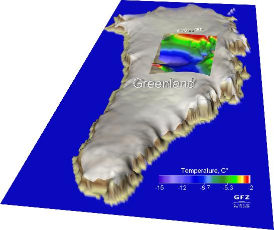
A press release from the GFZ German Research Centre for Geosciences: The Greenland ice sheet is melting from below, caused by a high heat flow from the mantle into the lithosphere. This influence is very variable spatially and has its origin in an exceptionally thin lithosphere. Consequently, there is an increased heat flow from the mantle and a complex interplay between this geothermal heating and the Greenland ice sheet. The international research initiative IceGeoHeat led by the GFZ German Research Centre for Geosciences establishes in the current online issue of Nature Geosciences (Vol 6, August 11, 2013) that this effect cannot be neglected when modeling the ice sheet as part of a climate study.

The continental ice sheets play a central role in climate. Interactions and feedback processes between ice and temperature rise are complex and still a current research topic. The Greenland ice sheet loses about 227 gigatonnes of ice per year and contributes about 0.7 millimeters to the currently observed mean sea level change of about 3 mm per year. Existing model calculations, however, were based on a consideration of the ice cap and considered the effect of the lithosphere, i.e. the earth's crust and upper mantle, too simplistic and primarily mechanical: the ice presses the crust down due to its weight. GFZ scientists Alexey Petrunin and Irina Rogozhina have now coupled an ice/climate model with a thermo-mechanical model for the Greenland lithosphere. "We have run the model over a simulated period of three million years, and taken into account measurements from ice cores and independent magnetic and seismic data", says Petrunin. "Our model calculations are in good agreement with the measurements. Both the thickness of the ice sheet as well as the temperature at its base are depicted very accurately. "

The model can even explain the difference in temperature measured at two adjacent drill holes: the thickness of the Greenland lithosphere and thus the geothermal heat flow varies greatly in narrow confines. What does this mean for climate modeling? "The temperature at the base of the ice, and therefore the current dynamics of the Greenland ice sheet is the result of the interaction between the heat flow from the earth's interior and the temperature changes associated with glacial cycles," explains corresponding author Irina Rogozhina (GFZ) who initiated IceGeoHeat. "We found areas where the ice melts at the base next to other areas where the base is extremely cold."

The current climate is influenced by processes that go far back into the history of Earth: the Greenland lithosphere is 2.8 to 1.7 billion years old and is only about 70 to 80 kilometers thick under Central Greenland. It remains to be explored why it is so exceptionally thin. It turns out, however, that the coupling of models of ice dynamics with thermo-mechanical models of the solid earth allows a more accurate view of the processes that are melting the Greenland ice....

Modeled basal ice temperatures of the present-day Greenland Ice Shield across the Summit region, GRIP and GISP2 indicate borehole locations. From the GFZ's website

Monday, July 15, 2013

New study indicates need for continuous satellite monitoring of ice sheets to better predict sea-level rise

University of Bristol press release: The length of the satellite record for the Greenland and Antarctic ice sheets is currently too short to tell if the recently reported speed-up of ice loss will be sustained in the future or if it results from natural processes, according to a new study led by Dr Bert Wouters from the University of Bristol.

The findings, published in Nature Geoscience, underscore the need for continuous satellite monitoring of the ice sheets to better identify and predict melting and the corresponding sea-level rise.

The ice sheets covering Antarctica and Greenland contain about 99.5 per cent of the Earth's glacier ice which would raise global sea level by some 63m if it were to melt completely.  The ice sheets are the largest potential source of future sea level rise – and they also possess the largest uncertainty over their future behaviour.  They present some unique challenges for predicting their future response using numerical modelling and, as a consequence, alternative approaches have been explored.  One common approach is to extrapolate observed changes to estimate their contribution to sea level in the future.

Since 2002, the satellites of the Gravity Recovery and Climate Experiment (GRACE) detect tiny variations in Earth’s gravity field resulting from changes in mass distribution, including movement of ice into the oceans. Using these  changes in gravity, the state of the ice sheets can be monitored at monthly intervals.

Dr Bert Wouters, currently a visiting researcher at the University of Colorado, said: "In the course of the mission, it has become apparent that ice sheets are losing substantial amounts of ice – about 300 billion tonnes each year – and that the rate at which these losses occurs is increasing.  Compared to the first few years of the GRACE mission, the ice sheets' contribution to sea level rise has almost doubled in recent years.”

Yet, there is no consensus among scientists about the cause of this recent increase in ice sheet mass loss observed by satellites.  Beside anthropogenic warming, ice sheets are affected by many natural processes, such as multi-year fluctuations in the atmosphere (for example, shifting pressure systems in the North Atlantic, or El Niño and La Niña events) and slow changes in ocean currents....

An iceberg off the coast of Tasilaq, Greenland, shot by Christine Zenino, Wikimedia Commons via Flickr, under the Creative Commons Attribution 2.0 Generic license

Tuesday, March 19, 2013

Significant contribution of Greenland's peripheral glaciers to sea-level rise

Science Codex: The scientists looked at glaciers which behave independently from the ice sheet, despite having some physical connection to it, and those which are not connected at all. The discovery, just published in Geophysical Research Letters, is important as it will help scientists improve the predictions of the future contribution of Greenland's ice to sea-level rise.

Using lasers which measure the height of the ice from space, and a recently completed inventory of Greenland's glaciers and ice caps, scientists from the European-funded ice2sea programme, were able to determine changes in the mass of those ice bodies, separate from the main ice sheet.

It also showed that the contribution to sea-level rise from the glaciers of Greenland separated from the ice sheet makes up around 10% of the estimated contribution of the entire world's glaciers and ice caps, and that contribution is higher than expected.

Lead author Dr. Tobias Bolch, from the University of Zurich, says, "The melting of ice on Greenland is known to be one of the major sources for global sea-level rise. Beside the large ice sheet, there are thousands of peripheral glaciers which are not connected to the ice sheet or can be separated from it due to the existence of ice divides. The area of those glaciers is about 50 times higher than the ice cover of the European Alps. Consequently, it is important to investigate not only the ice sheet but also these local glaciers."

The paper, "Mass loss of Greenland's glaciers and ice caps 2003 - 2008 revealed from ICESat laser altimetry data", showed glaciers with no or weak connection to the main ice sheet contributed to around 30 Gigatons (Gt) of water per year to sea level between 2003 and 2008.

When they added in glaciers which had some link to the ice sheet, but which were still distinct from it in the way they flowed, this figure increased to up to around 50 Gt per year. This yearly figure represents more than half the water contained in one of Europe's largest lakes, Lake Geneva. The study gives more detail to the make-up and stability of Greenland's glaciers showing that mass loss is highest in the warmer south east of the land mass and lowest in the colder north….

Tasilaq ice sheet in Greenland, shot by Christine Zenino, Wikimedia Commons via Flickr, under the Creative Commons Attribution 2.0 Generic license

Sunday, December 9, 2012

Wildfires darkening Greenland snowpack, increasing melting

Ohio State University: Satellite observations have revealed the first direct evidence of smoke from Arctic wildfires drifting over the Greenland ice sheet, tarnishing the ice with soot and making it more likely to melt under the sun.

At the American Geophysical Union meeting this week, an Ohio State University researcher presented images from NASA’s Cloud-Aerosol Lidar and Infrared Pathfinder Satellite Observation (CALIPSO) satellite, which captured smoke from Arctic fires billowing out over Greenland during the summer of 2012.

Jason Box, associate professor of geography at Ohio State, said that researchers have long been concerned with how the Greenland landscape is losing its sparkly reflective quality as temperatures rise. The surface is darkening as ice melts away, and, since dark surfaces are less reflective than light ones, the surface captures more heat, which leads to stronger and more prolonged melting.

Researchers previously recorded a 6 percent drop in reflectivity in Greenland over the last decade, which Box calculates will cause enough warming to bring the entire surface of the ice sheet to melting each summer, as it did in 2012. But along with the melting, researchers believe that there is a second environmental effect that is darkening polar ice: soot from wildfires, which may be becoming more common in the Arctic.

“Soot is an extremely powerful light absorber,” Box said. “It settles over the ice and captures the sun’s heat. That’s why increasing tundra wildfires have the potential to accelerate the melting in Greenland.”

... in the Arctic, rising temperatures may be causing tundra wildfires to become more common. To find evidence of soot deposition from these fires, Box and his team first used thermal images from NASA’s Moderate Resolution Imaging Spectroradiometer (MODIS) to identify large fires in the region. Then they used computer models to project possible smoke particle trajectories, which suggested that the smoke from various fires could indeed reach Greenland....

Glaciers and icebergs at Cape York, Greenland, shot by Brocken Inaglory, Wikimedia Commons, under the Creative Commons Attribution-Share Alike 3.0 Unported license

Monday, October 22, 2012

Ice sheet retreat controlled by the landscape

India Education Diary: A UK team led by Durham University has found that the geometry of channels beneath the ice can be a strong control on ice behaviour, temporarily hiding the signals of retreat. The findings, which provide the first simulation of past ice-sheet retreat and collapse over a ten-thousand- year period in Antarctica, shed new light on what makes ice stable or unstable and will help refine predictions of future ice extent and global sea-level rise, the researchers say.

The International Panel on Climate Change (IPCC) has stated that one of the main challenges in predicting future sea-level rise is to quantify and model the interactions between evolving ice sheets, oceans, sea level and climate. Significant efforts have been made over the last decade to develop computer models and collect data in order to reduce uncertainties and understand the potential impacts under scenarios of future climate change.

The results of the new research from Durham University, the University of Sheffield, the University of Cambridge, and the British Antarctic Survey are published in the journal Nature Geoscience. Lead author Dr Stewart Jamieson, a glaciologist at the Department of Geography, Durham University, said: “Our research shows that the physical shape of the channels is a more important factor in controlling ice stability than was previously realised. Channel width can have a major effect on ice flow, and determines how fast retreat, and therefore sea-level rise, can happen.

Although climatic and oceanic changes are crucial drivers of ice loss, the research shows that the landscape below the ice strongly controls the speed of any retreat. Dr Jamieson said: "Our results suggest that during an overall phase of retreat an ice stream can appear almost stable when in fact, in the longer-term, the opposite may be the case. Getting a clearer picture of the landscape beneath the ice is crucial if future predictions of change in the ice-sheets and sea level are to be improved.”...

Marine-based ice streams are the fast flowing arteries of ice sheets, draining approximately 90 per cent of the ice that reaches the sea. They flow through large channels where the ice can move thousands of metres in a year. According to the scientists, the unpredictable nature of ice streams makes forecasting ice-sheet retreat extremely difficult. If ice streams speed up they can cause sea level to rise....

Located just 600 miles (970 kilometers) from the North Pole, Franz Josef Land is perpetually coated with ice. Glaciers cover roughly 85 percent of the archipelago’s land masses, and sea ice floats in the channels between islands even in the summertime. The Advanced Spaceborne Thermal Emission and Reflection Radiometer (ASTER) on NASA’s Terra satellite observed the islands of central Franz Josef Land on August 16 and 19, 2011. (Another sensor on Terra captured a wider view on August 17, 2011.)

Wednesday, July 25, 2012

GPS can now measure ice melt, change in Greenland over months rather than years

Ohio State University: Researchers have found a way to use GPS to measure short-term changes in the rate of ice loss on Greenland - and reveal a surprising link between the ice and the atmosphere above it. The study, published in the early online edition of the Proceedings of the National Academy of Sciences, hints at the potential for GPS to detect many consequences of climate change, including ice loss, the uplift of bedrock, changes in air pressure - and perhaps even sea level rise.

The team, led by earth scientists at Ohio State University, pinpointed a period in 2010 when high temperatures caused the natural ice flow out to sea to suddenly accelerate, and 100 billion tons of ice melted away from the continent in only 6 months.

They were able to make the measurement because the earth compresses or expands like a spring depending on the weight above it, letting them use the Greenland bedrock like a giant bathroom scale to weigh the ice atop it. As ice accumulates, the bedrock sinks, and as the ice melts away, the bedrock rises. Measurements revealed that Greenland sank by about 6 mm (about one quarter of an inch) over the winter of 2010, and the researchers determined that half of the sinking (3 mm, or one eighth of an inch) was actually due to high air pressure above the ice, and the other half was due to ice accumulation.

Further, they determined that the bedrock lifted 11 mm (less than half an inch) over the course the summer. Air pressure appeared to affect the bedrock less during this time, so that the bounce-back appears to be mostly due to ice loss.

This method has been used to study ice loss before, in Antarctica as well as Greenland. But previously, GPS could only detect changes over a period of several years, said project leader Michael Bevis, Ohio Eminent Scholar in Geodynamics and professor in the School of Earth Sciences at Ohio State. While shortening the detection time to six months is a substantial advance, Bevis thinks his team will soon do even better....

Composite photograph of a GNET GPS unit implanted in the southeastern Greenland bedrock. Image by Dana Caccamise, courtesy of Ohio State University

Tuesday, July 24, 2012

Satellites see unprecedented Greenland ice sheet surface melt

NASA: For several days this month, Greenland's surface ice cover melted over a larger area than at any time in more than 30 years of satellite observations. Nearly the entire ice cover of Greenland, from its thin, low-lying coastal edges to its two-mile-thick center, experienced some degree of melting at its surface, according to measurements from three independent satellites analyzed by NASA and university scientists.

On average in the summer, about half of the surface of Greenland's ice sheet naturally melts. At high elevations, most of that melt water quickly refreezes in place. Near the coast, some of the melt water is retained by the ice sheet and the rest is lost to the ocean. But this year the extent of ice melting at or near the surface jumped dramatically. According to satellite data, an estimated 97 percent of the ice sheet surface thawed at some point in mid-July.

Researchers have not yet determined whether this extensive melt event will affect the overall volume of ice loss this summer and contribute to sea level rise.

"The Greenland ice sheet is a vast area with a varied history of change. This event, combined with other natural but uncommon phenomena, such as the large calving event last week on Petermann Glacier, are part of a complex story," said Tom Wagner, NASA's cryosphere program manager in Washington. "Satellite observations are helping us understand how events like these may relate to one another as well as to the broader climate system."

Son Nghiem of NASA's Jet Propulsion Laboratory in Pasadena, Calif., was analyzing radar data from the Indian Space Research Organisation's (ISRO) Oceansat-2 satellite last week when he noticed that most of Greenland appeared to have undergone surface melting on July 12. Nghiem said, "This was so extraordinary that at first I questioned the result: was this real or was it due to a data error? ....

Extent of surface melt over Greenland’s ice sheet on July 8 (left) and July 12 (right). Measurements from three satellites showed that on July 8, about 40 percent of the ice sheet had undergone thawing at or near the surface. In just a few days, the melting had dramatically accelerated and an estimated 97 percent of the ice sheet surface had thawed by July 12. In the image, the areas classified as “probable melt” (light pink) correspond to those sites where at least one satellite detected surface melting. The areas classified as “melt” (dark pink) correspond to sites where two or three satellites detected surface melting. The satellites are measuring different physical properties at different scales and are passing over Greenland at different times. As a whole, they provide a picture of an extreme melt event about which scientists are very confident. Credit: Nicolo E. DiGirolamo, SSAI/NASA GSFC, and Jesse Allen, NASA Earth Observatory